3D Wave Puts 3D Climate Change Models in the Palm of Our Hands
Projects Sponsor

Delta Management Group is the leading sustainability, ESG and clean tech focused search firm in Canada. Delta is proud to have founded the Canada's Clean50 Award program in 2011, and has been the primary sponsor for the past 13 years.
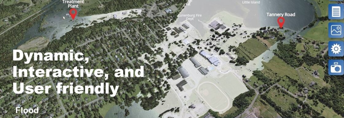
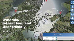
Their unique, innovative and Indigenous designed technology provides an interactive experience that allows nontechnical users — working on standard mobile devices — dynamic adjustment of scientifically accurate 3D digital elevation models with hydrodynamic SLR/Storm Surge/Fluvial flooding, wildland fires and other climate change events.
The global climate is changing and we see the impacts all around us. It’s in the rising sea level, the increasing frequency and intensity of storms, the river and overland flooding, wildland fires, and other events. Yet despite this escalating evidence many of us are still in denial about the climate crisis. We’re not acting fast enough and to Nova Scotia-based 3D animation and communications company, 3D Wave Design, that was a problem they knew they had the skills to help solve.
The team at 3D Wave gave a lot of thought to understanding why some, often very well-intentioned, people aren’t more proactive about implementing the measures necessary to protect their communities. The team came to the conclusion that for many, including those in governance, the inability to visualise the potential impacts of climate change was a barrier to getting the job done.
How do you effect real change when climate change is just a number?
Through their interviews with decision-makers, including elected officials, First Nation chiefs, mayors, councillors, and Nova Scotia’s Emergency Management Office and Operations personnel, the 3D Wave team concluded that even people who had received and read engineering studies and other reports relevant to the climate crisis seemed not to fully grasp their implications.
Existing data was numerical, or at best detailed in low-resolution 2D mapping, and the 3D Wave team realised they needed to develop an approach that would democratise climate science to better facilitate risk comprehension and adaptation.
The software they designed uses 3D modeling, laser scanning, and environmental data to help Atlantic communities make the kinds of choices that will help shelter them from the increasingly deadly results of climate change. It’s a unique and Indigenous-designed technology that incorporates Two-eyed Seeing and combines Western science, traditional knowledge, and a cultural approach to knowledge sharing.
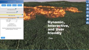
Allowing users to simulate conditions like storm surges, inland flooding, and wildfires, using real environmental, meteorological, and laser scanning data empowers stakeholders to act. With 3D Wave’s innovative software, what might have been represented by mere numbers on a page instead plays out as a simulation over geographically accurate 3D representations of real communities.
The 3D aspect of this project is key to its success and the team at 3D Wave knew it, and stuck to it. The federal government has just completed writing a national specification for 2D floodplain mapping. Their product had to be 3D. Full Stop.
To achieve this, the 3D Wave team needed to boil down gigabytes or even terabytes of LiDAR mapping and high-definition orthophoto images to just 10s of megabytes while maintaining high-fidelity digital elevation models. Once they had this base data, they could integrate the latest flood and fire climate science and connect it all up to purpose-built 3D modelling software, and finally wrap everything up with a custom web app to make it.
When they demonstrated their 3D interactive software to non-technical government decision-makers, they were excited by it. They got it.
Senior Engineering personnel, however, would often act as gatekeepers and not endorse the system. They weren’t as easily convinced of the need for a visual translation of the data. They could read it in the original.
It took years, perseverance, and much soul-searching before 3D could gain a broad acceptance but acceptance has poured in. Adoption and sales, both at the municipal and federal government levels, have been significant. Indigenous Services Canada’s Emergency Management Assistance Program supports the integration of their software and 3D Wave is also providing their 3D modeling to First Nations, global renewable onshore/offshore energy firms, global aquaculture companies, and academic institutions from one coast to the other.
Their approach allows non-technical decision-makers to comprehend climate change risk and review environmental impacts from renewable energy installations, aquaculture sites, and more. It can be used to inform and educate the public on the hard decisions to be made.
This is the future of climate change response. Now in 3D.