Creating a 3D Map of Canada
Projects Sponsor

Delta Management Group is the leading sustainability, ESG and clean tech focused search firm in Canada. Delta is proud to have founded the Canada's Clean50 Award program in 2011, and has been the primary sponsor for the past 13 years.
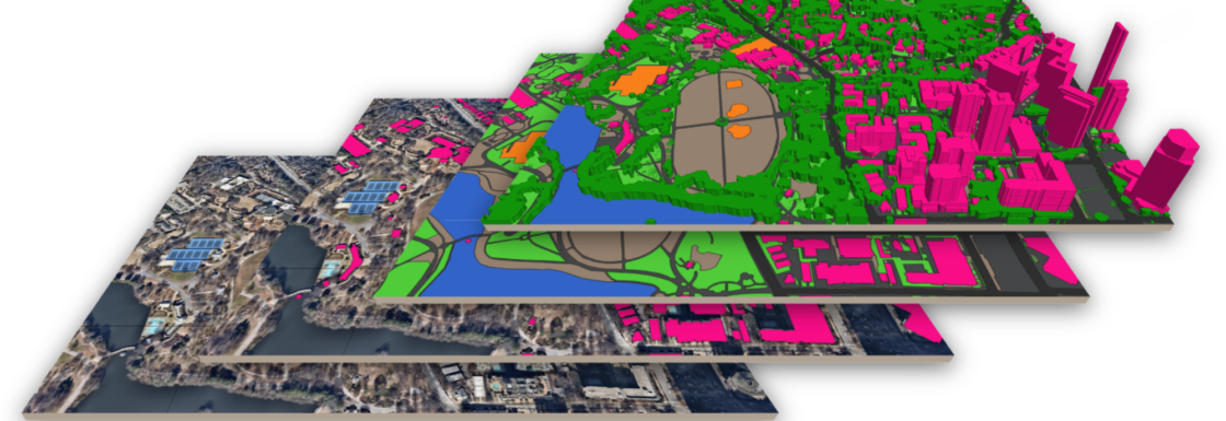
Ecopia’s Canadian 3D Mapping Initiative is creating the first-ever high-definition map of the top 100 cities of Canada. This map provides a level of detail 400x greater than the current maps used by government stakeholders. This map will support sustainability-related initiatives as part of the Canadian Government’s plan to achieve net-zero emissions by 2050.
Digital maps are more than just really cool, they help facilitate economic growth, community development, and perhaps most importantly, climate resilience. Detailed maps are a vital policy tool and yet, Canada has historically operated without a high-precision, uniform digital representation of its cities.Fortunately, Ecopia, a Canadian supplier of high-definition mapping products, is changing that by creating a digital representation of the top hundred cities in Canada. It’s an initiative that will help municipal stakeholders better understand and manage their cities and one that promises to accelerate the implementation of net-zero initiatives.
When experts are working from the best possible maps, rooftop solar installations, tree-canopy coverage assessment, and enhanced flood mapping, all become more feasible and more precise.
Ecopia’s research for their High-Precision 3D Map project began by identifying the level of detail and granularity currently offered by the maps being utilised by the Government of Canada. They also looked at many use cases or applications that a new high-definition map could serve. The team found that the maps the government uses are presently based on an input imagery resolution of 30m, which leaves a lot of room for improvement. The team engages with numerous Canadian municipal governments who are actively applying for federal funds from programs such as the National Disaster Mitigation program. Ecopia set out to leverage AI in order to create a 3D map in an accurate, comprehensive, and scalable manner, with a goal to quickly accomplish that.
The key objectives of Ecopia’s Canadian cities project were to create a high-definition 3D Map of Canada with the geospatial attributes that can help empower decision-making for critical sustainability initiatives. Applications beyond that include insurance, telecommunications, transportation, public safety, and much more. Knowing that infinitely more detailed maps offer an opportunity to increase the efficiency and accuracy of decision-making within cities, they wanted to ensure that municipalities and government stakeholders around the country had easy access to the data they created.
After the preliminary research, and with a clear understanding of their goals, they embarked on building an ecosystem of supporters, early adopters, and funding partners to support the creation of the first-ever 3D Map of Canada.
The original obstacles of mapping a large country like Canada in high-definition have already been tackled by Ecopia’s award-winning AI-based mapping systems, a result of continuous research and development since 2013. To generate their high-definition maps, Ecopia’s AI-based mapping system ingests high-resolution geospatial imagery sourced via their partners and outputs a high-definition map showcasing important natural and manmade features.
The result is the first-ever 3D Map of Canada, proudly created by a Canadian company with world-leading AI technology. The Canadian government (and the Minister of Innovation, Science and Industry) have recognized that Ecopia is doing its part in the fight against climate change and meeting Net Zero emissions targets Access to the HD map data will transform the way municipalities and industry stakeholders across a hundred cities in Canada make decisions on key infrastructure elements and sustainability initiatives.
Ecopia is giving us the tools we need to navigate our way to net-zero.