Smart Forest Reforestation
Projects Sponsor

Delta Management Group is the leading sustainability, ESG and clean tech focused search firm in Canada. Delta is proud to have founded the Canada's Clean50 Award program in 2011, and has been the primary sponsor for the past 13 years.
To tackle climate change and biodiversity loss, veritree launched their proprietary Smart Forests system. Smart Forests combines local ecology expertise with advanced tools like Lidar, satellite imagery and ground-based technology, including bioacoustic sensors, trail cameras, and dendrometers. In its first two years, this technology has been deployed across over 500 hectares in Alberta and B.C., informing and verifing the planting of more than one million native trees. These Smart Forests restore degraded land, support wildfire recovery, and are projected to sequester over 950,000 tonnes of CO₂ over the trees’ lifetime, delivering transparency, resilience, and long-term climate impact. From the satellites to the saplings, tech gives arboriculture a helping hand.
veritree’s Smart Forest project was launched to solve a growing, not-growing challenge. While many businesses want to invest in nature-based solutions, a lack of transparency and verifiable data has made it difficult to justify and scale financing. Existing reforestation efforts often fall short in providing the ongoing monitoring, proof of impact, and ecosystem-level insights companies require. veritree’s objective was to design a system, Smart Forests, that brings credibility and visibility to nature restoration, giving businesses the confidence to invest. By combining local ecological expertise with cutting-edge technology, veritree set out to create measurable, transparent, and long-term impact at scale.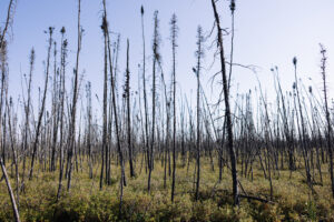
Before launching Smart Forests, veritree conducted in-depth research across multiple domains, including carbon sequestration science, monitoring technologies, industry protocols, and the needs of corporate sustainability leaders.
On the carbon side, the team examined peer-reviewed literature, global datasets, and established methodologies to build a robust, science-backed model for estimating carbon sequestration across different forest types. This research emphasized the importance of species type, survival rate, biomass distribution, and below-ground carbon storage. They also benchmarked field-verified tools like dendrometers and bioacoustic sensors, and evaluated satellite and Lidar technologies to ensure credible, scalable data collection.
Importantly, veritree studied corporate buyer expectations and recognized a critical trust gap. Traditional carbon or tree-planting programs lack ongoing measurement or ecological integrity. Companies are often keen to invest in environmental projects but lack of quantifiable data, can make it difficult to rationalize putting the cash into green. What was needed was a way to see the trees for the forest—and count them.
 These insights shaped Smart Forests: a system grounded in scientific rigor and transparency, with tools and methodologies that can evolve alongside emerging science. That means veritree now actively monitors projects, integrates field and remote sensing data, and continuously refine their carbon estimation models, helping businesses fund restoration with confidence and accuracy.
After completing research and setting their objectives, veritree began by identifying priority landscapes in Canada that aligned ecological need with restoration opportunity, focusing on wildfire-impacted and high-biodiversity areas in Alberta and British Columbia.
They worked closely with local experts and planting partners to assess site conditions, species suitability, and community engagement potential. This ensured each restoration effort was ecologically appropriate and socially inclusive.
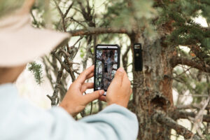
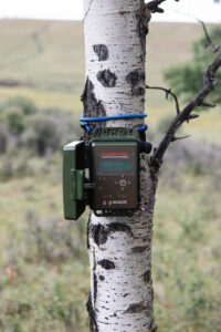
Before planting, the team established a baseline using remote sensing tools like satellite imagery and Lidar, combined with field data collection—installing dendrometers, bioacoustic sensors, and trail cameras to begin real-time ecosystem monitoring.
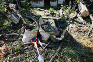
With ecological assessments in hand, planting implementation could get off (and into) the ground. veritree began tree planting, prioritizing native species that support biodiversity and long-term carbon capture. They tracked every tree with veritree’s verification platform and Collect App, ensuring traceability.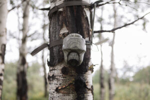
Post-planting, the team-maintained sensor networks and performed ongoing field verification. This allowed them to track tree survivability and ecosystem recovery.
All this field data was then translated into transparent, business-friendly dashboards and reports, enabling partners to see, share, and trust the impact they’re funding.
Of course there were some growing pains. The first Smart Forest in Cochrane, Alberta, taught veritree that restoring nature with data is not as simple as installing hardware in the ground.
They faced significant challenges with connectivity, equipment durability, and terrain access in this remote and rugged landscape. Devices like dendrometers and audio sensors—while promising on paper, struggled to withstand extreme temperatures, wildlife interference, and erratic power sources. Without consistent internet connectivity, real-time data uploads were also unreliable, leading to gaps in monitoring.
 But perhaps the most important realization was this: technology alone doesn’t tell the full story. Ground-truthing, especially in hard-to-access areas—is essential to validate remote measurements and provide context for anomalies.
These setbacks pushed the team to redesign our Smart Forest architecture from the ground up. They re-evaluated their sensor selection, prioritizing field-tested, durable hardware, and introduced hybrid data syncing models, allowing for offline collection with delayed upload capabilities.
Most importantly, they deepened collaboration with local planting partners to co-design data collection workflows that respect both ecological complexity and human capacity.
These learnings have directly informed the evolution of Smart Forest 2.0, where resilience, modularity, and ecosystem-specific customization are built into the design.
While the first Smart Forest didn’t deliver perfect results, it delivered something more valuable: the insights we needed to create a smarter, more scalable, and more impactful system for monitoring nature.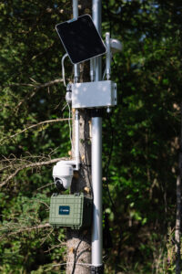
The Smart Forests project delivered measurable, transparent climate and biodiversity outcomes while building trust with corporate partners through data integrity and traceability.
Over a million trees were planted across wildfire-affected and high-biodiversity regions in Alberta and British Columbia, restoring over five hundred hectares of degraded land. These efforts are projected to sequester over 950,000 tonnes of CO₂ over the trees’ lifetimes, based on species-specific growth rates, survival rates, and our carbon models.
Each and every one of these trees is tracked via veritree’s digital verification platform, providing GPS coordinates, photos, and planting data for every site. Over twenty bioacoustic sensors, dendrometers, and cameras were installed to measure tree growth, forest health, and wildlife return.
Significantly, participating businesses received custom dashboards and impact reports. This verified partner transparency: enables them to communicate results confidently and avoid greenwashing.
 With results exceeding initial restoration and data verification goals, veritree is demonstrating how a, from satellite to sapling tech-enabled, science-backed approach can make nature investment measurable, verifiable, and trusted, unlocking new funding pathways for ecosystem restoration. In short, allowing companies to see the forest for the trees.